


When a powerful Atlantic hurricane makes headlines, UK residents naturally wonder about potential impacts closer to home. Hurricane Erin, which became the first major hurricane of the 2025 Atlantic season in August, has drawn considerable attention from meteorologists tracking its path across the Atlantic Ocean. While the hurricane Erin UK weather forecast has evolved significantly since Erin first formed, understanding what this system means for British weather requires looking beyond sensational headlines and examining the science behind how Atlantic storms influence our climate.
This comprehensive guide, published by The London Magazine, explains what Hurricane Erin is, how it developed, and what UK residents can realistically expect from its remnants. We’ll explore the meteorological processes at work, compare this system to past events, and provide practical information without unnecessary alarm.
Current Status of Hurricane Erin Uk Weather Forecast
Hurricane Erin Uk Weather Forecast originated from a tropical wave off the coast of West Africa in early August 2025. The system moved westward over Cape Verde on August 11, where it brought devastating flooding that killed nine people and forced hundreds to evacuate.
On August 15, the system strengthened into a hurricane northeast of the Lesser Antilles. Within just 24 hours, Erin underwent what meteorologists call “extreme rapid intensification,” jumping from a Category 1 to a Category 5 hurricane. Peak sustained winds reached 160 mph on August 16, making Erin only the 43rd Atlantic hurricane to achieve Category 5 status since records began in 1851.
Understanding Rapid Intensification
The storm’s explosive strengthening was fueled by exceptionally warm sea surface temperatures, measuring approximately 1.2°C above normal for the region. Climate scientists at Climate Central noted these unusually warm waters were made up to 100 times more likely by climate change, contributing an estimated 9 mph to Erin’s wind speeds.
After reaching peak intensity, Erin underwent natural weakening cycles as it moved northward along the eastern United States seaboard. By late August, the system had moved into the North Atlantic and begun its transition toward Europe. Understanding the hurricane Erin UK weather forecast requires recognizing where Erin is now and what changes it has undergone.
What Does “Ex-Hurricane” Mean?
“Ex-Hurricane Erin” or “post-tropical cyclone Erin” describes a storm that has transformed from a tropical system into an extratropical one. Hurricanes get energy from warm ocean waters, with a warm core and organized thunderstorms around a calm eye.
As Erin moved north, it encountered cooler waters—UK seas are typically 15–20°C in late summer, too cold to sustain a tropical hurricane. Losing its warm core, Erin began drawing energy from temperature contrasts between air masses.
This extratropical transition makes the storm asymmetric, with fronts and an elongated structure. Winds can remain strong, but their distribution and behavior change.
Why This Matters for the UK
The UK experiences extratropical weather systems year-round. Ex-hurricanes can influence UK Weather like Atlantic lows, but sometimes carry more energy and moisture, occasionally causing stronger impacts depending on track and jet stream interaction.
How Hurricane Erin Could Influence UK Weather
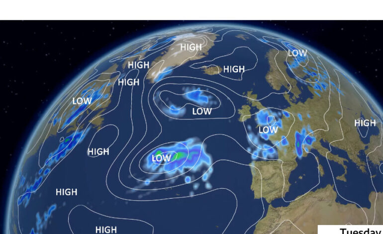
The evolution of the hurricane Erin UK weather forecast through late August 2025 demonstrated both the complexity of Atlantic weather patterns and the uncertainty inherent in long-range forecasting. According to Met Office forecasters, ex-Hurricane Erin moved into the Atlantic west of Ireland and the UK during the final week of August, bringing a period of more unsettled conditions after a stretch of high pressure and warm weather.
The interaction between ex-Erin and the jet stream was critical in determining its influence. The jet stream acts as a steering mechanism for weather systems. When ex-tropical systems approach the UK, their position relative to the jet stream determines whether they bring wet and windy conditions or remain offshore.
Regional Variations in Impact
Weather charts showing pressure systems and rainfall probability indicated that western Ireland experienced the most pronounced effects, with rainfall totals of 50-80mm forecast across counties facing the Atlantic, Northern Ireland, and the Outer Hebrides of Scotland. These totals accumulated over several days rather than falling in a single deluge.
Wind gusts remained moderate by Atlantic storm standards. The most exposed coastal areas of western Ireland, Northern Ireland, and western Scotland experienced gusts of 70-90 km/h (approximately 45-55 mph). Central and eastern parts of the UK saw considerably less impact, with southern England experiencing only brief periods of unsettled weather.
Temperature Changes and Forecast Uncertainty
Ex-Hurricane Erin’s approach created an interesting temperature pattern across the UK. Ahead of the system, southerly winds drew warm air northward from Spain, bringing temperatures of 28-30°C to parts of southern England on the August Bank Holiday Monday. However, this warmth proved short-lived, with temperatures dropping back to seasonal norms as cooler, maritime air moved in behind the system.
Why Forecasts Change Frequently
One of the most challenging aspects of forecasting was the significant uncertainty that persisted until just days before Erin’s arrival. Forecast models showed considerable disagreement about the system’s exact track, timing, and intensity. This uncertainty stems from the complex interaction between ex-tropical systems and the jet stream, which is sensitive to small changes in initial conditions.
Ensemble forecasting, which runs the same model multiple times with slightly varied starting conditions, helps meteorologists understand forecast confidence. When ensemble members show wide disagreement, confidence is low. In ex-Erin’s case, the model agreement improved significantly only 3-4 days before the system influenced the UK weather.
Understanding UK Weather Charts
Modern weather forecasting relies heavily on analyzing various types of charts that show different aspects of atmospheric conditions. Pressure charts display the positions of high and low-pressure systems at sea level, with isobar spacing indicating wind strength. When ex-Erin approached the UK, pressure charts showed a deep low (central pressure around 960 mbar) positioned west of Ireland.
The Role of the Jet Stream
Upper-level charts showing winds at approximately 30,000-40,000 feet reveal the jet stream’s position, strength, and shape. In ex-Erin’s case, the jet stream’s interaction with the transitioning storm determined whether the UK experienced significant impacts or whether the system remained offshore.
Rainfall probability maps proved particularly useful, illustrating how western areas had a high probability of significant rainfall while eastern regions had lower confidence for substantial amounts. Wave height forecasts predicted the 8-10 meter swells that affected western coasts during ex-Erin’s passage.
How Meteorologists Interpret These Charts
Professional forecasters synthesize information from multiple numerical weather prediction models, including the European (ECMWF), American (GFS), and UK Met Office models. Each has strengths and weaknesses, and comparing their solutions helps identify areas of agreement and disagreement.
For ex-Erin, forecasters monitored how different models handled the extratropical transition, the jet stream interaction, and the subsequent track. As observations improved and the event drew closer, model consensus converged on a northerly solution, allowing forecasters to provide more confident guidance.
Comparison – Typical UK Storm vs Ex-Hurricane
| Feature | Typical UK Atlantic Low | Ex-Hurricane System |
| Wind strength | Moderate to strong (40-70 mph gusts) | Moderate, occasionally strong (45-70 mph gusts) |
| Rainfall | Showery or persistent, 15-40mm typical | Heavier bursts possible, 30-80mm in exposed areas |
| Temperature | Seasonal or slightly below | Brief warmth ahead, then seasonal or cooler |
| Duration | 1-2 days of unsettled weather | Several days of changeable conditions |
| Regional variation | Often widespread impacts | Typically concentrated in west/northwest |
| Coastal impacts | Rough seas, moderate waves | High waves (6-10m), significant coastal effects |
| Frequency | Typically concentrated in the west/northwest | 1-3 times per decade |
This comparison illustrates that while ex-hurricanes can bring notable weather changes, they typically don’t produce extreme conditions for most of the UK. The systems behave more like particularly energetic Atlantic lows rather than tropical hurricanes.
Practical Implications for UK Residents
Travel and Transport Considerations
Road conditions were most affected in western regions during ex-Erin’s passage. Heavy rain reduced visibility and created surface water, particularly in areas receiving 50-80mm over 24-48 hours. Rail services in western areas experienced some delays and speed restrictions, though these disruptions remained relatively minor compared to major winter storms.
Ferry services to and from Ireland, the Western Isles, and other island communities faced the most significant disruption. High seas and strong winds prompted cancellations of several crossings during the peak of ex-Erin’s influence. Air travel saw minimal impact for most passengers, with some flights to Irish and Scottish islands experiencing delays or diversions.
Coastal Safety
Ex-Erin’s most dramatic impacts occurred along western coasts, where the combination of large Atlantic swells, strong onshore winds, and spring tides created hazardous conditions. Wave heights of 8-10 meters affected the western shores of Ireland, Northern Ireland, and the Outer Hebrides.
Rip Current Dangers
These conditions generated several safety concerns. Rip currents become more prevalent and stronger during large swells. During ex-Erin’s influence, lifeguards and the RNLI strongly advised people to stay out of the water in affected areas. Beach erosion was notable in parts of western Ireland and Scotland, with some beaches losing several feet of sand.
Outdoor Activities and Events
The timing of ex-Erin’s influence during the late August Bank Holiday weekend created concerns for those with outdoor plans. However, the UK’s west-to-east weather divide meant experiences varied dramatically. Western areas saw unsettled conditions with periods of rain and gusty winds, while much of central and eastern England enjoyed decent Bank Holiday weather.
Can the UK Be Hit by a Real Hurricane?
The UK cannot be struck by a true hurricane as defined by meteorological standards. Hurricanes require sea surface temperatures of at least 26-27°C extending to significant depth, minimal vertical wind shear, and a moist atmosphere with unstable air. The UK’s waters fail the temperature requirement even in late summer, when waters typically range from 15-19°C.
Sea Surface Temperature Requirements
Sea surface temperature reflects the heat content of the upper ocean. Hurricanes draw energy by evaporating warm water, with the resulting water vapor condensing in towering thunderstorms and releasing latent heat. This process requires not just warm surface temperatures but a deep reservoir of heat extending 50-100 meters below the surface.
When a hurricane crosses sea surface temperatures below about 24-25°C, its warm core begins to deteriorate. This typically happens well south of the UK, usually when systems are still 1,000-2,000 kilometers away. Even in exceptionally warm years like 2025, when the North Atlantic measured about 2°C above average, waters near the UK remained too cold for tropical maintenance.
Media Coverage and Misleading Headlines
Headlines may warn that a “hurricane” is heading for the UK, technically correct in that the system once held hurricane classification, but deeply misleading about what UK residents will actually experience. By the time any such system influences British weather, it has transformed into an extratropical low-pressure system.
Some headlines emphasize wind speeds from when the system was at hurricane strength thousands of kilometers away. Hurricane Erin UK Weather Forecast: 160 mph winds occurred near Puerto Rico, not anywhere near the UK. By the time ex-Erin influenced British weather, sustained winds over Ireland peaked at around 50-60 mph.
Lessons From Past Ex-Hurricanes
Hurricane Ophelia 2017
The most prominent recent case is ex-Hurricane Ophelia in October 2017, which remains the strongest ex-tropical system to impact the region in over 50 years. Ophelia formed unusually far east in the Atlantic and took an extremely rare direct track toward Ireland and the UK.
The storm made landfall in southwestern Ireland on October 16, 2017, with wind gusts reaching 119 mph at Fastnet Island. Mainland Ireland experienced gusts of 70-80 mph, with similar or slightly lower speeds across Northern Ireland, western Scotland, Wales, and western England. The storm caused three fatalities in Ireland and power cuts affecting over 300,000 homes. Total insured losses exceeded $87 million.
Historical Context
Statistical analysis of Atlantic hurricanes since 1950 shows that approximately 1-3 systems per year track close enough to potentially influence UK weather, though many bring only peripheral effects. Significant impacts affecting wide areas occur perhaps once every 3-5 years on average. Major events comparable to Hurricane Ophelia occur perhaps once or twice per decade.
Why Erin Was Different From Ophelia
Ex-Hurricane Erin’s influence proved notably less severe than Ophelia’s 2017 impacts. Ex-Erin tracked further north and west, keeping its most intense winds over the open Atlantic and western Ireland. While Erin was an extremely powerful Category 5 hurricane at its peak, it had weakened considerably before completing its extratropical transition.
The jet stream configuration during ex-Erin’s approach steered the system in a way that limited UK impacts to western areas. Ex-Erin moved relatively slowly, allowing it to gradually weaken over cooler waters, whereas Ophelia accelerated as it approached Ireland, maintaining more energy through its faster movement.
Forecast Confidence Timeline
Forecast clarity typically improves according to a relatively predictable timeline for ex-tropical systems:
10-14 days ahead: Models can identify that an ex-tropical system may influence UK weather, but with very low confidence about specifics. Wide disagreement exists about track, timing, and intensity.
7-10 days ahead: Some model consensus begins emerging about general scenarios. Forecasts become specific enough for tentative planning.
5-7 days ahead: Confidence increases substantially. Models typically agree on broad impacts, allowing forecasters to identify regions at higher risk and issue early advisories.
3-5 days ahead: Details become clearer about timing, intensity, and specific impacts. Weather warnings can be issued with appropriate confidence.
1-3 days ahead: High confidence exists for most aspects of the forecast. Rainfall amounts, wind speeds, and timing can be specified with useful precision.
For Hurricane Erin Uk Weather Forecast in late August 2025, this timeline held. Speculation about possible UK effects began around August 20, roughly a week before ex-Erin influenced western areas. Meaningful forecast confidence emerged August 23-24, with weather warnings issued August 25-26.
Key Takeaways for UK Readers
What is likely:
- Ex-tropical systems like Erin influence UK weather 1-3 times per decade, typically August-October
- Western areas experience the most significant impacts (50-70 mph gusts, 30-80mm rainfall)
- Most of the UK experiences only modest disruption, with eastern areas seeing minimal impacts
- Travel delays and power cuts may occur in western areas during peak influence
- Coastal waves of 6-10 meters affect western shores
What is unlikely:
- The UK is being struck by an actual hurricane with tropical characteristics
- Widespread catastrophic damage across the entire UK
- Wind speeds exceeding 80-90 mph except in most exposed coastal locations
- Major disruption to areas east of a line from Bristol to Edinburgh
Why staying informed matters:
- Forecasts improve dramatically as events approach, making daily updates valuable 3-7 days before impacts
- UK weather varies significantly between western and eastern areas
- Local weather warnings provide specific guidance and should be heeded when issued
- Each ex-tropical system is unique; past events provide context but not precise templates
Final Thoughts
Ex-Hurricane Erin demonstrates that while 1–3 Atlantic tropical systems may influence UK weather annually, significant impacts occur less than once per decade. Western regions faced gusts of 50–70 mph and 30–80 mm of rain, while eastern areas remained largely unaffected. Staying informed via Met Office updates, monitoring local warnings, and planning travel or outdoor activities accordingly are key. Understanding these patterns helps UK residents prepare sensibly for ex-tropical systems without unnecessary alarm.
Frequently Asked Questions
Will Hurricane Erin cause weather warnings in the UK?
Yellow warnings covered ~15% of UK regions: Northern Ireland, western Scotland, and Wales. Central and eastern areas experienced minimal impact, with most areas seeing <10 mm rainfall.
When will the UK feel Hurricane Erin’s effects?
Impacts began ~10–12 days after formation. Forecast confidence improves 3–5 days ahead, with winds reaching 40–50 mph in western areas and rainfall up to 20 mm.
Is this unusual for UK weather patterns?
On average, 1–3 Atlantic hurricanes or tropical storms influence the UK yearly. Only ~20% of these systems bring noticeable rain or wind.
Should I cancel outdoor plans for Hurricane Erin?
Western UK may see gusts of 40–50 mph and 10–20 mm of rain. Central and eastern regions usually experience <5 mm rain; cancellations are rarely needed.
How does Hurricane Erin differ from typical UK storms?
Typical UK lows have winds of 30–40 mph. Erin, an ex-tropical system, carried extra tropical moisture and energy, increasing rain potential by ~25% compared with standard Atlantic storms.